
Rip Currents 101
The greatest fear of many beachgoers is sharks—just mentioning the word conjures up a mixture of fear and fascination in the human psyche. We never seem to hear enough about these denizens of the deep, which are often regarded as monstrous “killing machines.” In reality, only one person on average is killed annually in the United States by sharks, which pales in comparison to the 100+ people who drown and tens of thousands of swimmers who struggle in the deadly rip currents each year. Clearly rips are the real killers. Yet most people do not even think about rip currents, much less fear their power or even know how to recognize them.
During the long hot summer, nothing is more refreshing than taking a plunge into the sea at your favorite beach. Never mind that the waves look a little larger than normal or no lifeguards may be on duty, the urge is almost irresistible. A big beach party at American Beach, Florida in 1994 ended in disaster when five people were pulled offshore to their death. The culprit was a rip current—a concentrated flow of water that can jet you offshore in a matter of seconds. Unfortunately, these beachgoers did not know how to spot these killer currents and were totally unprepared to deal with this phenomenon when caught by these seaward rushes of water.

Most beachgoers are only vaguely familiar with beach hazards and the threat to their personal safety. While coastal scientists have long studied waves and currents, the media are much less aware of the circumstances that can lead to drowning. Newspaper accounts of beach tragedies often lay the blame on nebulous causes, such as undertow, freak waves, or collapsing sand bars. As Dr. Andy Short of Australia has pointed out, these catchy and alarming terms may have little relevance to the actual circumstances that contributed to the accident.
THE SURF BEACH
One of the things that make ocean beaches so appealing and exciting is the surf—waves are the heart beat of the ocean. We are naturally drawn to the rhythmic pounding of the waves as if returning to our primordial beginnings. I can spend hours gazing out at the ever-changing shore. The fresh salty air invigorates the body as the sheer beauty and dynamic interplay between the waves and beach captures the imagination and refreshes our psyche. Also, nothing is more fun than jumping into the water and playing in the surf, feeling the power of the waves crashing ashore. Unfortunately, the unpredictable nature of the surf and its power result in many injuries and deaths each year, even affecting experienced swimmers and surfers.

The 6,000 or so waves that strike a beach every day are generated by the wind. Generally speaking, as the wind speed increases so does the surf. Waves that break on beaches can be locally generated or be spawned thousands of miles away by storms at sea. Hurricanes cause the largest waves, termed swell, along the Atlantic coast, while migratory low-pressure cells (e.g., storms) at high latitudes generate the great Pacific Ocean swells. The north shore of Oahu, Hawaii is directly exposed to these giant ocean swells that can reach 30 feet high during the international surfing contests in January. These huge swell waves are hitting beaches when the weather is perfect—sunny and cloud free.
Wave height is the primary determinant of rip current strength, but wavelength is also significant. Wavelength refers to the width of the wave, which is measured from trough to trough. The height and width determines the volume of water in a wave. Some waves that peak when breaking may appear powerful, but there is no real force behind them without a large mass of water. I have sometimes been fooled while boogie boarding on the Carolina coast by these waves with little punch. By contrast, the big swells that dominate the Pacific coast tend to have long wavelengths, making them very powerful waves that break with considerable force.
It is nearly impossible to measure wavelength when in the water, but you can easily count in seconds the time between waves as they break. The greater time between plunging breakers (termed the wave period), the longer their wavelength and consequently the greater the force for a wave of a particular height. Long-period swell waves of around 20 seconds are the best surfing waves along the Southern California coast, but these turbulent waters are best avoided for swimming; I suggest heading to the nearest heated swimming pool.
High waves can be quite dangerous. What is not understood by the public is that the energy is proportional to the height of the wave squared. Therefore, a three-foot wave is nine, not three, times more powerful than a one-foot wave. Onshore breaking waves that exceed five feet are generally too dangerous for bathers and swimmers. Experienced surfers look for the big waves, but good surfing beaches are often dangerous for swimming.
The two primary types of breaking waves are plunging and spilling. Plunging waves are by far the most exciting and dangerous, being characterized by great force and velocity. Plunging breakers are formed when swell suddenly encounters a shallow bottom, such as a reef, large sand bar or steeply-sloping beach. The wave is forced to peak up and break suddenly with all of its force concentrated in a limited area. Plunging waves often generate rip currents and shorebreaks on steep beaches and are responsible for many more injuries than spilling or surging waves.

Spilling breakers, which are more common and much less imposing, lose their energy over long distances in contrast to plunging waves. The breaking water rolls or tumbles forward as the wave advances into shallower water, producing a wide surf zone. Spilling waves generally provide safe conditions for waders, swimmers, and boogie boarders; the U. S. East and Gulf coast beaches are most often subject to this type of breaking waves.

WHAT CAUSES RIP CURRENTS
Waves contain the energy that generates currents at beaches. These currents are the ones that primarily affect bathers and swimmers and extend from the shoreline to the outermost breakers (e.g., the surf zone). Tidal jets are another dangerous current (totally unrelated to waves) that occur locally at inlets or other constrictions; these strong currents are caused by the flooding and ebbing tides.
Wave breaking produces swash—the water that moves up and down a beach face. The sheet of water moving up the beach is called the swash uprush or just uprush. The larger the breaking wave, the deeper and faster moving is the uprush. The swash that does not sink into the sand is then drawn by gravity down the beach as water seeks its own level. When the waves are high and the beach is steep, the swash backwash can be powerful and is sometimes called undertow, which can knock you around, but is seldom a problem except for children.
Undertow, which is strong backwash, only pulls you into, but not beyond the wave breaking on the beach. The effect of the wave breaking over the top of you can give the impression of being sucked under the wave, hence the concept of undertow.
Some beach communities, especially along Southern California and Hawaii, post signs warning swimmers of undertow during big wave days. Undertow is the one thing that many beachgoers have heard about, yet the real danger is rip currents.

On big wave days, especially with large plunging breakers, the swash can be quite strong; the water shoots up the beach face, providing a good ride for boogie boarders. The backwash of the swash is particularly problematic on steeply-inclined beaches near the time of high tide. This return flow of water that is caused by gravity can topple people--it is difficult to maintain your footing in the swift current as you are pulled forcefully toward deeper water. While this current can be overpowering during times of big plunging waves, it will not take you beyond the breaker line (unlike a rip current which carries you offshore through the surf zone). Of course, it can be dangerous if you are pulled into the next large plunging wave that is breaking into shallow water (e.g., shorebreak conditions).
The most frequently encountered current by bathers and swimmers on ocean beaches is the longshore current, which is produced by waves breaking at an angle to the shoreline. Anyone who has spent time on surf beaches has experienced this current that moves you along the shore, but not offshore. Sometimes the current is so gentle that you don’t even feel it moving you; it is not until you get out of the water to find your towel that you realize its effect. Other times, especially when the breaking waves are coming from an oblique angle to the shoreline and are quite large, this current can feel like a river flow (you really should not be in the water during these conditions). In fact, the longshore current is responsible for huge quantities of sand movement, making beaches a “river of sand.”
Rip currents are caused by water being pushed up the beach above mean sea level by large breaking waves. Swashes generated by plunging breakers of large swell waves are the most effective in producing the conditions for rip generation. As in the normal swash process, this water that is piled up on the beach is subject to gravity, pulling it back down the slope to the sea surface. Subsequent large breaking waves can continue to pile the water up on the beach, causing a temporary damming effect. Water will follow the path of least resistance, such as an underwater trough or along a groin, in seeking its own level. A concentrated flow of returning water to the ocean becomes a rip current, moving away from the beach toward the offshore.
The bigger the breaking waves, the more water that is trapped on the beach face, and consequently the stronger the rip. Therefore, rip currents vary greatly in size and power. Rip tide is a misnomer because tides play no role in causing these strong offshore flowing currents.

RECOGNIZING AND ESCAPING RIPS
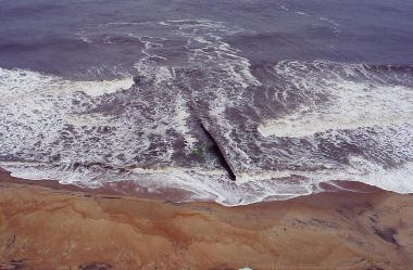
The United States Lifesaving Association (USLA) estimates that 80% of all ocean rescues are caused by rip currents. This statistic indicates the huge importance of recognizing what many people consider to be a “hidden danger.” Many tourists and others unaccustomed to the ocean often have difficulty spotting these deadly killers; even lifeguards and coastal professionals cannot spot them when the wind is blowing onshore, creating confused sea conditions. Waves break in a water depth that is 1.3 times their height. Because rips flow through underwater channels or breaks in the inner bar, waves do not break as readily here. Also, the force of the rip current itself tends to diminish the power of the incoming waves, lowering the surf. Some unsuspecting bathers and swimmers can even be attracted to rips because of the calmness of the water relative to the high surf elsewhere.
It is important for people to learn how to spot rips because it can literally be a matter of life and death; even expert swimmers can be nearly helpless in these powerful currents. Rips are sometimes referred to as the “drowning machine” because of their almost mechanical ability to tire swimmers, causing fatigue and ultimately death. The first thing I do upon arriving at a beach is to scan the surf from the highest point possible. Also, I consult with lifeguards on surf conditions and especially regarding the presence and location of any rip currents. Rips do not always appear in the same spot every time, but can change position. More than one rip may be present at the same beach on the same day. I always look for a seaward flow of debris or entrained sediment. In rip currents these materials generally move at right angles to the shoreline. Where the rip crosses the surf zone, the line of breakers may be interrupted or transformed into small, choppy waves. Also, the water contained in the rip often looks murky or foamy. Rip currents moving through relatively calm, regular surf of big Pacific swells, such as along the Southern California coast, are easily detected. By contrast, these deadly currents are much harder to spot when the sea is rough and conditions are windy.
Rip currents have three components—feeder, neck and head. This is the classic diagram of rip currents; oftentimes this mushroom shape is not present or apparent to beachgoers from the vantage point of the water’s edge.
The feeder current is the main source of water for the rip. Water that has been pushed and piled up on the beach is often moved along the shore for a short distance by the feeder currents to the underwater channel or trough. Once the water reaches the channel or encounters an obstacle to its along-the-shore movement, it will turn seaward as a rip current. There may be one or two feeder currents, depending upon the wave approach and prevailing longshore current.

The neck section is where the concentrated flow of water moves from the beach through the surf zone. Current speeds are quite fast, often reaching 2-3 feet per second and measured to be as high as 6 feet per second along some Australian high-surf beaches. The neck of the rip can vary in width from a few yards to tens of yards. The majority of both rescues and drownings occur when people are being pulled offshore in the rip neck.
The rip head, which sometimes has the classic mushroom shape, develops where the current has moved beyond the surf zone. Here the rip loses its power as the water disperses broadly (see red arrow in figure). There is no longer a current, and anyone being pulled to this offshore area can then just swim back to shore, avoiding the narrow rip neck. I once tried this strategy at Ocracoke Island, North Carolina, but it took me almost an hour to swim (with periods of floating to rest) back ashore the several hundred yards in high seas (see East Coast).
Another way to escape from a rip is to swim perpendicular to the pull of the current (e.g., parallel to the beach). Unfortunately, most people caught in rips tend to panic. Our survival instinct tells us to swim back toward the beach, which is absolutely the wrong thing to do. Even champion swimmers that attempt to swim against strong rips will fatigue and eventually drown.

SIGNS—LOOK CAREFULLY FOR TELLTALE SIGNS OF RIPS BEFORE ENTERING THE OCEAN:
Change in water color from the surrounding water (either murkier from sediments, seaweed, and flotsam or darker because of the depth of the underwater channel where the rip flows).
Gap in the breaking waves, where the rip is forcing its way seaward through the surf zone.
Agitated (choppy) surface that extends beyond the breaker zone.
Floating objects moving steadily seaward.
Water in the rip may be colder than the surrounding water.
WHAT TO DO—IF CAUGHT IN A RIP CURRENT:
Don’t panic, which wastes your energy and keeps you from thinking clearly.
Don’t attempt to swim against the current directly back to shore.
Swim parallel to shore until you are out of the current as the offshore flow is restricted to the narrow rip neck.
Float calmly out with the rip if you cannot break out by swimming perpendicular to the current. When it subsides, just beyond the surf zone, swim diagonally back to shore.
EAST COAST
My first beach experiences were at Myrtle Beach, South Carolina when it was still a small beach town, consisting mostly of one and two-story white wooden houses. As a young boy, I lobbied my parents to come back to the beach every summer as opposed to making the mountain trip because playing in the waves was so much fun. I was a good swimmer and had no fear of the water; only my parents waving kept me from going too far offshore. The waves were relatively small and safe, but still fun for a kid to ride. Rips rarely occur at Myrtle Beach, which was fortunate because I had no knowledge of these offshore-directed currents. The sand here is very fine, which makes the beach flat and slope gently into the water. Barring an offshore hurricane or frontal system moving through the area (two major wave generators), it is a safe beach for families.
If you are heading to the Georgia coast for a beach vacation, don’t bother packing the surfboard. Rips are not present in flat water, such as in ponds or bays, and are not a problem when the wave action is limited (e.g., waves measured in inches). The tides are large, but the waves are usually small. The shallow continental shelf extends out for hundreds of miles, which contributes to the larger tidal range along with the shoreline configuration (the “Georgia bight,” which is concavity that is clear on maps of the U. S. East Coast). The rising water is simply “bunched up” so that the tide must come in higher along Georgia relative to the states on the flanks—North Carolina and Florida. The larger waves break many miles offshore. Small waves that do reach shore are spilling-type breakers, which also most frequent the South Carolina coast.
The first time I saw a rip current was at the groin field near the Cape Hatteras lighthouse. Many people confuse groins and jetties. Groins are coastal engineering structures, typically made of wood, sheet metal, or rock, that extend perpendicular from the beach out into the water. Groins are often built in a series along the beach constituting a “field.” By contrast, jetties are used to stabilize inlets for navigational purposes and are much larger structures, constructed out of large rock boulders or concrete tetrapods.
The groins at Cape Hatteras were wooden and fairly short, but rip currents are commonly produced on this high-energy beach as the strong longshore current is directed offshore by these blocking structures. Experienced surfers routinely use the rip currents to take a free ride offshore on their boards, and then ride the breaking waves ashore. Swimmers are advised to avoid being near groins in all cases because of the possibility of being slammed into these hard structures by breaking waves or being swept offshore by rip currents.
The Outer Banks of North Carolina are famous for many things—the first English colony in the New World, the place where the Wright Brothers first took flight, and the home of Blackbeard the pirate. In recent years it has become a surfing mecca because of the large swell-type waves that arrive especially in late summer. Duck, a community named for the hunting camps of an earlier time, has become one of the favorite beach escapes for Washingtonians and other urban dwellers looking for upscale restaurants and accommodations. I especially like to gather together family and/or friends and rent one of the large wooden beach houses on the high rolling sand dunes that characterize this section of the barrier island. The beach is composed of coarse sand and pea-sized gravel that is reddish in color. The coarse sand translates to a steeply grading beach into deeper water so that waves can come close to shore before breaking. I recommend that families with children visit these shores early in the summer when the waves are relatively small.
During the late summer, especially August and September, the Atlantic Ocean really becomes stoked by tropical storms and hurricanes in the tropical latitudes. Big swell waves can travel for thousands of miles without losing their energy until they break upon the beach. In these cases, dangerous surf can be produced as well as the life-threatening rip currents. A number of people have been drowned on the Outer Banks in recent years because they do not understand or recognize these powerful offshore-flowing rip currents.
The most instrumented beach in the world is at Duck—the U. S. Army Corps of Engineers Field Research Facility. Touring this facility, which was formerly a bombing range during World War II, you will discover how coastal scientists and engineers make measurements of waves and currents as well as record changes in the beach and nearshore areas. A high-resolution videocamera has been installed in the tower overlooking the beach. This beachcam provides streaming video of the surf zone, which can be used to analyze the changing position of the underwater bars (by inference of the breaking wave patterns) and possible presence of rip currents.
Rip currents at Duck persist for weeks or even months at the same places, moving through underwater channels or breaks in the inner bars. Only a particularly large winter storm (e.g., nor’easter) or hurricane moves and/or destroys these channels—conduits for the seaward-flowing currents. Some rip currents lasted from May until September according to Dr. Robert Dean, a colleague at the University of Florida. This finding contradicts the prevailing view of rip currents as spontaneous and short-lived events. While they may exist at the same position for months, they only become strong (and hence noticeable and dangerous) with the approach of large swell waves producing plunging breakers. Certain sections of the shoreline appear to be more prone to rip currents than others, but no systematic studies have been undertaken.
Ocracoke Island, south of Cape Hatteras, is only accessible by ferry boat or small airplane. I really enjoy visiting this getaway island that was the home to Blackbeard the pirate before he was killed here and beheaded. These were wilder times, but the 16-mile long beach at Ocracoke can be pretty wild itself with the big roller breakers. During earlier times, I was in peak shape and a good swimmer. A few buddies of mine decided that it would be fun to test personally the strength of a rip current, which was probably not the brightest idea that we ever had. As it turns out, the rip was a bit bigger than we anticipated, and we were pulled a few hundred yards offshore in fairly deep water before we were released from the current’s grip. We should have bailed out by swimming alongshore out of the confined flow area, but macho was the order of the day. I had not counted on the difficulty of swimming ashore in waves that topped 10 feet. Wave size is limited by the depth of water; waves can reach in height a maximum of 0.6 times the water depth. I always like to tell my students that you cannot have 5-foot waves in a mud hole. In this case, we were well beyond my normal limits. It took us nearly hour to swim back ashore, and we were totally exhausted from this experience--that I do not intend to repeat. I have spent many pleasurable summers working on the south shore of Long Island, New York. This area gets some good wave action, especially during late summer because of the tropical storms in the lower latitudes. Jones Beach State Park on the south shore of Long Island, New York is the most popular and heavily visited beach in the U.S. Northeast coast. Over six million people per year congregate on this strand of barrier beach. The beach resembles a patchwork quilt from the vantage point of my aerial overflights--the towels on the beach nearly touch end-to-end and side-to-side. Surprisingly, the people who frequent Jones Beach like it that way; this is truly a touchy-feely beach, but will never rank high in my ratings as the most popular beaches are rarely the best beaches.
Strong rips occasionally develop, and the mere multitude of people forces unwitting bathers into the swift offshore-flowing current. Lifeguards have had to pull out hundreds of people from a single rip current during an exhausting weekend of duty. In this special case, the presence of the rip is recognized, but the “crowd pressure,” like rush hour on the subway, can nudge you into the current.

Further west along the south shore of Long Island at the Rockaways, fierce rips have killed many swimmers over the years. During July 2001, three teenage girls were wading in knee-deep water at Far Rockaway in Queens when they were swept away by a rip toward Reynolds Channel (tidal inlet with jet) and then offshore to their deaths. Their mother stood on the shore helplessly and said that the ocean “…just opened its mouth and swallowed them up.” This area has been called a death trap, and few dare to swim here, even with lifeguards. It is advisable to never swim or wade near an inlet as the tidal currents can carry you far offshore. This area seems to be a double whammy (e.g., rips and tidal jets) for beachgoers who want to take a dip in the water.
Rip currents typically form in pronounced breaks or “holes” in the nearshore bar, which serve as the conduits for the strong seaward-flowing current. Such strong currents could scour holes in the inner bar, but what caused the rip to form in the first place? This is the proverbial “chicken and egg” question. These “holes” in the inner bar also cause problems of exacerbated beach erosion during storms as the waves break closer onshore and with more energy in these areas. Localized beach erosion at Fire Island and the Hamptons, the barrier beaches to the east, occurs during storms because of this phenomenon.
Most of the drownings along the Atlantic Ocean beaches in the Hamptons occur in August. Red flags are flown by the Towns of Southampton and East Hampton to indicate strong currents, but not everyone heeds these warnings or swims at protected beaches with lifeguards. August is the time when the water is the warmest, most people are in the water, and hurricanes hundreds to more than a thousand miles away are kicking up the waves that come ashore here as swell-type plunging breakers. Clearly, people need to recognize the telltale signs of rips.
I spent many summers on Cape Cod while directing the National Park Service Research Unit at the University of Massachusetts in Amherst. One of the beaches of particular interest was Nauset Spit in Chatham. There are no paved roads on the long barrier beach so access is by boat across the bay or off-road vehicles. In the late 1970s, I was heading up an Earthwatch expedition, and we stayed in the Old Harbor Station—one of the original late 1800s Life-Saving Stations complete with tower. It was a great experience living in this landmark building that had been brought close to the water’s edge by progressive beach erosion.

At high tide the water nearly lapped onto the front porch. At low tide the beach was much more expansive as the tides here are quite large (six feet during full moon). The nearshore bar is nearly exposed at dead low tide and often exhibits a crescent shape with low areas or “holes” in the bar at a regular spacing of several hundred feet. During mid to high tide with good surf (e.g., 3 to 5 foot plunging breakers), I have often observed rip currents being set up, with this swift current moving through the holes in the bar. I advised my team members not to go swimming during these conditions in the chilly water that rarely reached 65 degree Fahrenheit even on a hot summer day. While we were conducting some research elsewhere on Nauset Spit, a teenage boy decided to go swimming, and he was swept offshore by a rip current that persisted right off the Old Harbor Station. We were really saddened to learn of this tragic death, and I wish I had been there to warn him of these silent killers. Rips are weak or not present during low tide because there is not enough water depth. From mid-tide to high tide, the inner bars serve to trap the wave runup (swash) of the breaking waves; this elevated water then flows alongshore to the position of holes in the bars where the rip currents form.
While a professor at the University of Maryland, College Park, beach erosion and storm impact at Ocean City, Maryland got a lot of my attention. During the 1970s this small seaside resort was transformed into a boomtown with high-rise condominiums and hotels replacing wooden houses and small motels. The barrier dune was bulldozed down in order to allow building closer to the water’s edge and to provide the first floor occupants an unobstructed view of the ocean. All of this construction was undertaken without any consideration whatsoever of beach erosion. I suppose ignorance is bliss until a winter storm cuts away the beach, making the view of the ocean “too good” and finally bringing home the reality of the situation. Ocean City had a major beach erosion problem, which required public assistance. The U. S. Army Corps of Engineers was very accommodating and restored the beach and dunes at a cost of over $80 million. Most of my time at Ocean City was spent dealing with beach erosion and storm impact, but shorebreaks seem to be more problematic after beach rebuilding with the coarser sand that was pumped ashore from the offshore shoals. There have been a number of shorebreak accidents, including broken necks, along the re-nourished Delaware beaches, which tend to be fairly steep. The problem occurs when plunging waves break directly on the beach face; an unsuspecting bather, swimmer or boggie boarder can be thrown head-first into the sand with devastating consequences.
A family from Boston, making their annual pilgrimage to Ocean City, arrived in early evening. The young Kennedy boy was eager to get into the water so his father went to the beach with him after the lifeguards had retired. The lifeguards always close the beach when the breaking waves reach 5 feet or higher. They are off-duty by 6 PM. The surf was high in late August 1995 because of “heavy” weather at sea caused by Hurricane Felix. The father and son walked along the beach until they found an area of lower than average waves. Thomas Kennedy, a 10-year old boy, was only up to his waist when he felt the strong tug of the rip current. His father grabbed his hand and anchored his feet in the shifting sand, but the current was too strong for his grip. The boy’s hand slipped away, and his father watched in horror as his son Thomas was swept offshore to the deep ocean waters; there was absolutely nothing that could be done in this circumstance. The body was later recovered by the U. S. Coast Guard, floating near Ocean City Inlet.
A classic mistake was made by these Bostonians. They entered the water where it appeared to be the safest, but actually walked right into a deadly rip current. This strong, offshore-moving current was literally knocking down the waves. They were in the wrong place at the wrong time. I was interviewed by the Baltimore Sun newspaper and the local press to explain how this terrible mistake could have been made. The father later called me and said he wanted to do something to warn others; he was terribly distraught by this very personal tragedy. He wanted to install signs and diagrams depicting and warning about rips along the Ocean City boardwalk, but the city managers were not in favor of this action. They maintained that rips are quite rare occurrences, and such signs would only serve to scare people and business away from their beach. This episode really stimulated my interest in being pro-active, which eventually lead to the development of a new water tracer for rip currents see www.ripcurrents.com. There are now warning signs for rip currents at Ocean City, Maryland and most U.S. beaches.

I use to take my kids to a surfing spot in South Florida. They really like to boogie board, but you have to look out for the long boarders who try to surf right into the swash zone. One afternoon, the lifeguards were flying red flags for a rip current alert. There were a lot of kids in the water, and the waves were low—only a few feet high and obviously not dangerous as I scanned the clear, greenish-colored water. I asked the young lifeguard about the warnings and pointed out that there were no rip currents present. He said that there were rips earlier in the morning and was disinterested in further conversation. Such false warnings give people the wrong impression about rip currents, in specific, and beach safety, in general. Next time that dangerous rips are actually lurking, people may not take the lifeguards seriously and ignore their warnings.
The surf at Miami Beach is generally low during the summer, but the winter nor’easters that cause considerable erosion along the mid-Atlantic and northeastern coasts produces some big swell waves in these subtropical climes. Rips often occur during the winter and early spring when the long-crested swell waves approach the beach directly onshore. Many rip rescues occur during “Spring Break” because of the large number of college students that have limited experience swimming in the ocean. While these swell waves are generated far out at sea, strong onshore winds locally can also generate large surf. Rips are expected on days with strong onshore winds and become particularly dangerous as the breaking waves approach 4 to 5 feet in height. Statistics from lifeguards indicate that most of the drownings occur at low tide on this microtidal (less than 3 foot tidal range) shore. Interestingly, drownings that I investigated on the mesotidal (greater than 6 foot tidal range) coast of outer Cape Cod occurred at mid to high tide.
Volusia County on Florida’s northeast coast accounts for the majority of rip current rescues in the state. In a typical year, two to three thousand people have to be pulled out of these waters, especially during the summer months; these same waters, especially at New Smyrna Beach, are also known for their shark bites. This large number of rip incidents is probably related to the popularity of the Volusia County beaches and their long length, extending tens of miles. Some experts also believe that the shifting bars and underwater channels also make this beach strand more susceptible to rip currents. Fortunately Daytona Beach has an excellent team of lifeguards, and beachgoers should also swim near a guard.
GULF COAST
The Gulf of Mexico is not the ocean, which is apparent to anyone accustomed to the pounding California surf or the summer swell-type waves of the Atlantic Ocean. This is good news for people prone to seasickness like myself; an offshore boat trip in the Gulf means cutting through small chop, rather than pitching and rolling in the heavy seas of the Atlantic or Pacific Oceans. The surf is only up big-time when tropical storms come knocking, and the Gulf of Mexico is known as hurricane alley. Frontal systems can also kick up the surf locally, causing strong rips and all too many drownings.
The Gulf Coast is characterized by beaches with long, gradually sloping bottoms, which generally prevent the build-up of the pounding surf on the beach. The Gulf waters are usually placid to choppy so that big breaking waves only occur when there is an offshore storm or passing frontal system in this great water basin. Taken together, this means that rip currents are infrequent here relative to the Atlantic and especially the Pacific coast beaches. When the water is clear and the surface calm, submerged crescent-shaped bars may be visible in the nearshore area, close to the beach face. Presence of this unique “rhythmic” topography of the inner bars sets the stage for rip current formation if large breaking waves approach the beach.
Panama City Beach is located in the Florida panhandle along the famed “Emerald Coast” so named because of the beautiful clear, turquoise waters. This long strand of barrier islands also boasts of the finest, whitest sand in the world (albeit someone who has explored a beach in faraway Kenya is now challenging this claim to fame). I can remember the first time I ever saw these sugar sand beaches as a young boy. I started running into the warm waters, expecting to tumble forward when tripped by the deepening water. Instead I just keep running and running and still the water was not that deep, much to my surprise. The super fine sand means that the beach is very flat and gently slopes into the water, which makes for an exceptionally safe beach in combination with the almost placid seas. But any beach can be dangerous on a given day, and people must remember that beaches are not swimming pools.

Panama City Beach is where the now famous research by Dr. Choule Sonu was conducted on rip currents. He chose this area for his field experimentation because of the clear warm waters. Fluorescent dye was used to trace the motion and time the speed of the rip currents. During 5-foot waves, which only rarely break on these normally placid shores, Choule measured maximum rip speeds at 2 to 3 feet per second. The nearshore bar often contains large gaps where the rip currents can naturally form when the seas are pumped up by an offshore storm. Sadly, every few years someone from the heartland of America, who is not familiar with the ocean, is drowned here by a rip current.
PACIFIC COAST
Surfing in Southern California was immortalized by songs, such as “Surfin’ USA” by the Beach Boys and “Surf City” by Jan and Dean. The big ocean swell that rhythmically beats along these shores are great surfing waves. The plunging breakers also generate large swash that “sets up” (e.g., elevates) the water on the beach, well above the average water level. This elevated water must escape back to the sea. Some of it moves back seaward as backwash, but a portion is often moved along the shore by feeder currents to a rip current. I have often marveled at how well organized the nearshore circulation system is, which includes the regular spacing of large rip currents along the shore. The tell-tale signs of the plume of seaward flowing water caused by these big rips are apparent from the beach, but are the easiest to spot from cliffs or fishing piers. I always take time to gaze at the impressive rip currents along Huntington Beach, California when visiting my relatives. The community of Huntington Beach boasts of its title as “Surf City, USA,” and surfers are not bothered by the rips; indeed they use them to take a free ride offshore to catch the next set of big waves.
Rip currents, not sharks, are the bane of Southern California beaches for swimmers. Thousands of people are rescued each year by the well-trained lifeguards. One tends to think of the former TV series Baywatch, which was filmed at Venice Beach, and the shapely female lifeguards in the red bathing suits. While most of the action at Venice Beach is on the concrete boardwalk, the lifeguards that roam the beach in their bright yellow, 4-wheel drive trucks make quite a few rescues.
Ocean Beach in San Francisco, California is where I take the TV people looking for rip currents to photograph because of a recent drowning elsewhere. The best way to see the full extent of these offshore flowing waters is from the air. For the TV shoots, the producers rent a helicopter, and I drop fluorescent dye to visually trace these powerful currents. Rip currents are a regular occurrence along the only ocean beach in San Francisco, and swimming is never permitted along this high-surf beach. Unfortunately, some out-of-towners each year try to take a dip, and are pulled several hundred yards offshore where they drown in the frigid waters. I believe Ocean Beach should be renamed Killer Rip Beach; perhaps visitors would then take note and stay out of the water.
Anyone unfortunate enough to be sucked offshore by the big rips at Ocean Beach would also be subject to the strong tidal currents. During a flooding or rising tide, your body, long since chilled down by the very cold waters, would be carried beneath the Golden Gate Bridge and pass by Alcatraz Island. It has been said that no one ever escaped Alcatraz when it was a maximum security prison because of the strong tidal currents and hypothermia that swimmers experience within half an hour.

The most popular swimming and surfing beach in the San Francisco area is Stinson Beach in Marin County. Stinson has good amenities, and the beach is quite popular, particularly with the younger crowd who can tolerate the water. The water is at its warmest in the summertime, but is still chilly by East Coast standards. When the big Pacific swell starts coming ashore, one and occasionally two big rips are set up near the middle of this pocket beach. The lifeguards mark the rips with flags to warn swimmers. At Stinson Beach, you can have it all—big powerful rip currents and the most fearsome of all sharks—the great whites. While this beach definitely sounds like a place to avoid, there are remarkably few drownings and shark attacks are generally just bites to surfer’s legs.
Hawaii is America’s tropical paradise and boasts of some of America’s best beaches. Many of the National Winners are Hawaiian beaches, and I have often been asked why all the top beaches are not in these tropical isles where the mountains meet the sea. The major reason involves beach safety because of the big waves, shorebreaks, and dangerous rip currents. What is really interesting about Hawaiian beaches, where the water is warm enough to going swimming year round, is how much the waves change seasonally.

The big surfing beaches are on the north shore of Oahu, which is the surfing capital of the world. Here the Pacific Ocean swells normally reach 20 feet in height and can tower to an incredible 30 feet or more. Waimea Bay is internationally known for having the largest ridable surfing waves in the world. This U-shaped pocket beach is bounded by cliffs, which make great viewing of these terrific and terrifying breakers. The huge plunging breakers form a cone of air through which these brave (and some say foolish) surfers take the ride of their life. During the winter, waves breaking on the offshore coral reef provide some of the most awesome and dangerous surf imaginable. Lifeguards use jet skis for rescues, but they must pick their entry time just right between mountainous seas. During the summertime, these same waters can be as quiet as a lagoon. The contrast is startling, and it makes you wonder if you are really at the same place. While swimming is a pleasure in the summer, don’t even think about getting into the water from September to April.
Most rip currents are generated by large waves, often plunging breakers. But there are other conditions when rips can be generated. All that is really required is to “set” or stack the water up above sea level and have a constricted area for the return flow offshore. Such a location exists at Kee Beach at the literal end of the road and gateway to the Na Pali Coast, Hawaii’s premier wilderness experience.
Kee Beach on the island of Kauai has sensational scenery. Sheer mountain cliffs with intermittent waterfalls provide a dramatic backdrop for this small pocket beach. The quiet, blue-green water serves as one of the most popular snorkeling sites in Hawaii, where you can swim with schools of brightly colored tropical fish. Waves breaking over the coral reef, exposed at mid to low tide, results in elevated water being trapped at Kee Beach. The super-elevated water cannot escape easily through the coral rock that surrounds this little beach, except through a channel on the western end of the reef. Unsuspecting swimmers and snorkelers paddling around the quiet waters of this lagoon-like setting can suddenly find themselves caught in a powerful rip current, which has caused a number of drownings. The lack of high surf at the water’s edge does not always assure safety. Lifeguards should always be consulted when entering the water.
RIP STATISTICS
Eighty percent of ocean rescues (over 70,000 per year) involve saving someone caught in a rip current.
A strong rip current moves at 3 feet per second, which is as fast as an Olympic swimmer in a 50-meter sprint.
Rip currents have been measured to have speeds as high as 5 feet per second at big surf beaches in Australia. Rips often occur at groins, jetties and piers; stay at least 100 feet away from these structures in the water to avoid these deadly currents and other hazards.
About 100 people drown annually in rip currents in the United States.
Breaking waves that approach 5 feet can generate powerful rip currents. The energy of a wave is proportional to its height so that a 3-foot wave is 9 times more powerful than a 1-footer.